The Office of Emergency Management (OEM) was joined by city departments, elected officials, and community partners on Saturday, May 9, to launch a new public flood monitoring system that allows real-time access to water level data to better prepare for and respond to flooding events.
The announcement, marked by a ribbon-cutting ceremony during Eastwick Community Day in Southwest Philadelphia, introduced OEM’s web-based technology that allows residents and businesses to check flood conditions across the city from their phones or computers.
Flooding remains one of the most common and costly natural disasters affecting Pennsylvania, often developing quickly with little warning. This new system provides critical, real-time information to help Philadelphians make informed decisions to protect their families, homes, and businesses from rising water that can overwhelm creeks, rivers, sewers, or streets.
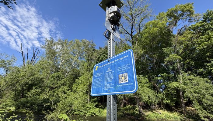
How the Flood Monitoring System Works
The system currently includes nine locations across Philadelphia, with monitoring points along key waterways and street locations including:
- Darby Creek
- Cobbs Creek
- Pennypack Creek
- Manayunk Canal
- Kelly Drive and Midvale Avenue
- Bayton Street and Church Lane
- Godfrey Avenue and Beechwood Street
Residents can access the system at flood-monitoring.phila.gov to:
- View real-time water levels and conditions
- Search by address or location
- Monitor rainfall, water temperature, and barometric pressure
- Watch live camera feeds of flood-prone areas
Camera and gauge information is available by choosing a location on a map, entering an address, or choosing a specific gauge or camera.
This technology allows residents and businesses to view water levels from their home computer or mobile device to help make informed decisions on how to prepare or respond to forecasted or developing flooding. This includes raising or moving important items from lower levels of residents’ and businesses’ properties, ensuring important documents or medications are organized, moving vehicles to higher ground, or even leaving your property until the storm threat passes.
The new website also provides access to other resources, like common flooding terms, flood insurance information, and ways to lessen the risk of flooding around your property. Instruments collect and display a wide range of data, including information on water levels, rain amount, barometric pressure, and water temperature.
Expanding Emergency Preparedness
OEM’s initiative builds on the City’s ongoing work in Eastwick, a neighborhood that has experienced significant flooding from storms like Tropical Storm Isaias (2020) and Tropical Storm Ida (2021). In response, the Office of Emergency Management OEM launched ReadyPhiladelphia Eastwick Alerts, the City’s first neighborhood-targeted emergency messaging system. Today’s announcement is the next phase of the citywide flood technology project, which involves a pilot program that will bring added attention to rising water levels with the installation of gauges and cameras in flood prone areas.
“The Eastwick initiative is a great example of how we are uniting as “One City” to ensure Philadelphia is safer, cleaner, and greener,” said Dominick Mireles, Deputy Managing Director, Community Safety. “Listening to residents, addressing their concerns, and incorporating their ideas into potential solutions is critical to creating safer and stronger communities. I’m proud of the inter-agency collaboration by our City departments in cooperation with our residents to provide them with the emergency awareness and preparedness tools and resources they need to be more prepared for flooding.”
This pilot program follows other recent expansion of public awareness products and programs by City departments.
OEM’s Alert and Warning program broadened its ReadyPhiladelphia emergency messaging system by translating key alerts into multiple languages, including American Sign language.
The City’s Office of Sustainability (OOS) Recovery to Resilience initiative has been working with Eastwick residents to develop a strategy to address flooding since 2022. The Eastwick Flood Resilience Strategy is a community-driven long-term plan to address current and future flood impacts in Eastwick. OOS is also working on a near-term flood barrier project to address current flood impacts.
Built with Community Input
This investment reflects the City’s commitment to delivering visible, neighborhood-level solutions that improve public safety and resilience—especially in communities most impacted by climate-related challenges.
By combining real-time data, community engagement, and interagency coordination, Philadelphia is strengthening its ability to respond to emergencies and protect residents before, during, and after severe weather events.
The flood monitoring project was developed in partnership with residents and multiple City agencies, including the Flood Risk Management Task Force. The project became a reality through the Chief Administrator’s Office and the City Operations Transformation Fund grant that was secured by OEM’s Operations Division.
The Office of Sustainability, PhillyCounts, and Better Services PHL worked to ensure residents’ voices were part of the process through focus groups, surveys, and other outreach methods. The Philadelphia Department of Streets, Philadelphia Water Department, Philadelphia Office of Clean and Green, Philadelphia Office of Innovation and Technology, John Heinz National Wildlife Refuge, and the US Environmental Protection Agency assisted in installing the flood gauges, technology, camera systems, and website development.
Stay Connected and Prepared
Sign up for ReadyPhiladelphia to get the latest forecast, timing, hazards, and protective action information from the City receive real-time updates on severe weather and flooding:
- Text READYPHILA to 888-777.
- Customize alerts by location and hazard type by visiting OEM’s website.
- Access information in 11 languages, including American Sign Language.