Blog by Joanna Hecht, Pitch and Pilot Fellow, Office of Innovation and Technology
This blog post is part of a series that covers the first two years of the SmartCityPHL program.
Every year, the Streets Department publishes a list of streets that will be resurfaced. There are a number of factors that determine which streets will be paved next. One of those factors is the scoring assigned to a street during roadway inspection.
Previously, Streets Department inspectors would team up to drive the city and record where cracks and potholes had appeared. Their ratings would factor into the year’s resurfacing schedule. It’s a time-intensive process and pavement inspection is only a small portion of the inspectors’ jobs. With other competing duties, both routine and unexpected, reviewing all of the city’s 2,400-plus miles of roadways each year was challenging.
In mid-2020, amid drastic budget cuts and the COVID-19 pandemic, the SmartCityPHL team partnered with the Streets Department to change this process. The goal was to use technology to automate the inspection process to evaluate many more miles of streets each year. With a comprehensive, up-to-date view of the city’s roadways, the Streets Department could extend its planning horizon from three to five years to better align with the five-year capital budgets set out by the City and utilities.
The Streets Department aims to let data drive the decision-making—and not just data about pavement conditions. A comprehensive look at city-wide road conditions, when combined with demographic and socioeconomic data, can help the City to prioritize repairs in underserved communities. By using this data to identify and support the most in-need areas, the project aligns with the City’s commitment to embed racial and economic equity in its budgeting process.
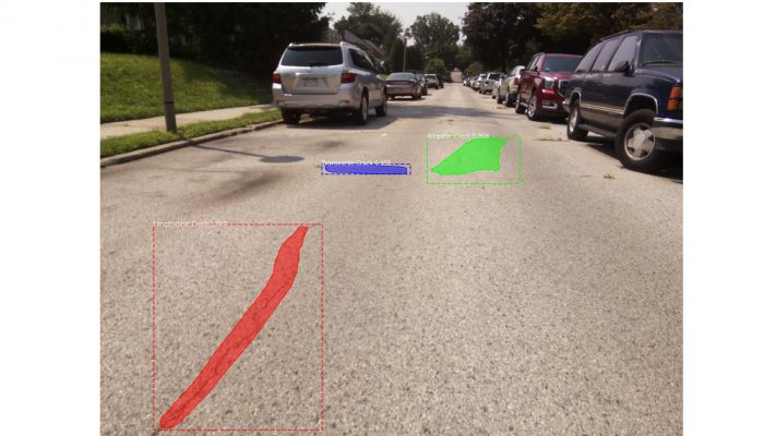
It was with this broader goal in mind that the City issued a request for proposals in the summer of 2020 for affordable, automated pavement assessment. GoodRoads, a company based in North Carolina, was selected as the vendor and partner for a 1,200-mile pilot project. City inspectors attached the company’s low-cost, portable devices to their existing vehicles and captured images of the streets as they drove the city roads.
In just 438 hours of driving, the inspectors captured more than one million unique images of the roadways. GoodRoads analyzed images of the City’s prioritized 1,200 miles for cracks, potholes, and manhole covers, allowing the Streets Department to develop a comprehensive view of needed repairs. At the same time, GoodRoads trained their artificial intelligence platform to identify locations of road signs and faded pavement markings—laying the groundwork for the City to incorporate other safety considerations into their review and funding prioritization.
The continued development of new types of analysis is a unique feature of the collaboration between the City and GoodRoads. If funding is approved to scale up the project, the City and GoodRoads plan to inspect the remaining 1,200 miles of the City’s roadways and develop additional uses for the imagery. The City and GoodRoads have discussed the potential to examine other features of the public realm, like assessing litter conditions, examining the structural integrity of foundations, and mapping assets.
Ultimately, the data will be analyzed with respect to race, poverty, and geographic concentration of needed repairs to create an equitable approach to roadway maintenance in Philadelphia. Long-term planning and routine street inspections will help the City use its resources more effectively. By allowing broader goals to lead the piloting and procurement of new technology, Philadelphia embodies smart city innovation.