The Office of Innovation and Technology (OIT)’s CityGeo team helps all City departments share data for mapping, analysis, and city services. Philadelphia’s approach to the data management process is unique.
Typically, a city’s Geographical Information System (GIS) team is separate from the ‘data programs’. Philadelphia’s approach has been the opposite. OIT recognized that GIS staff around the City already had decades of experience standardizing, analyzing, visualizing, and presenting the City’s data. This put those individuals in the best position to lead the way for data across the City.
Through ongoing development of intuitive digital tools, our City government increases residents’ access to information they need. For example, Atlas.phila.gov allows homeowners, title companies, and others to explore everything from a property’s deed history to information on the next election and polling place, recent and nearby crime incidents, and more.
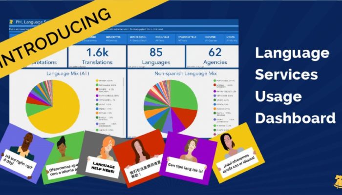
Interactive dashboards also make city government more transparent. They help residents find information for their personal, communal and professional goals. Philadelphians can access the Campaign Finance Dashboard, Open Data Dashboard, Language Access Dashboard, and other online tools. These are available to residents, but also researchers, data scientists, and journalists.
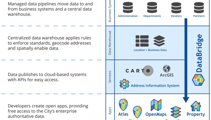
The proven success of this model has largely been built on the ‘DataBridge’ program, the name of the City of Philadelphia’s enterprise data sharing and integration platform. DataBridge allows for improved data hygiene and datasets. The program is managed by the CityGeo team.
Here are some of the things DataBridge does:
- Acts as a centralized data sharing platform/warehouse
- Breaks down ‘departmental siloes’, making it easy and routine for departments to share data
- Lessens the amount of integration points necessary across the City
- Allows for easily managed access controls for individual datasets, integrations and APIs
- Enterprise support for dependent workflows into and out of platform
- Works for all datasets, with additional strengths in handling spatial records
These digital tools are visible outcomes of data management and governance. As we improve data management and standards, interactions with city government will become smoother over time. Residents benefit from cross-department coordination. Collaboration between technical experts with subject matter experts helps the City build useful tools and streamline efforts to keep them updated. This means subject matter experts at departments can contribute their data regularly, but not get bogged down in manual efforts to clean and load it and instead focus on their core program goals.