Members of the Philadelphia Fire Department (PFD) use tools like hoses, ladders and axes to fight fires and rescue people from emergencies.
But, did you know that technology is an important tool for the Fire Department as well?
Let’s talk Geographic Information Systems (GIS)
GIS is a key part of ensuring that the Fire Department functions as it should. GIS is basically the foundation for collecting, managing, and analyzing data. It’s primarily focused on geography—in other words, it specifically deals with location data and organizes it into visualizations.
So, why would GIS be important for the Fire Department?
GIS helps the Philadelphia Fire Department plan and strategize much better through mapping. The department—with its team of GIS analysts—has created many mapping tools to make its internal data more accessible and easier to understand. One tool is a paper map repository and online map request system. PFD members can go to the departmental intranet and view coverage maps for every station in the city and submit requests for custom maps—such as areas that have seen increased fire and/or Emergency Medical Services activity. This can help the PFD target fire prevention efforts like smoke alarm installations, for example.
GIS analysts have also developed several web-based data collection tools to help departmental units better track and manage their data. For instance, an app created for the naloxone leave-behind program allows the PFD to track where paramedics and Emergency Medical Technicians have distributed overdose-reversal kits to civilians. This helps identify neighborhoods that have been most affected by the opioid epidemic.
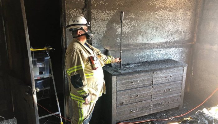
Another project involved creating an online investigation workbook for the Fire Marshal’s Office to replace the previous paper-based system. The online form allows PFD members to work on investigations in the field and store their info in a secure, centralized database that can be referenced in digital dashboards and reports. This new application and workflow will make the Fire Marshal’s Office more efficient and allow for real-time reporting.
An innovative project
Earlier this year, the Fire Department was selected to receive funding through one of the City’s Innovation Fund grant cycles. The department proposed a project for 360-degree cameras that would be used by the Fire Marshal’s Office to help investigate the causes and origins of fires and lessen the time that investigators spend in burned buildings—meaning less exposure to toxic smoke and residue. Currently, investigators can take hundreds of photos on a fireground, which might take hours. The 360-degree camera will cut this investigation time in half.
As the Philadelphia Fire Department continues to provide incredible service to the community, it also relies on technology and innovative thinking to lead the way to a more accessible and progressive future.